SmartMast™ · Environmental Intelligence
Turn the World's Commercial Fleets into a Global Ocean Observation Network
SmartMast enables persistent, real-time environmental intelligence by transforming commercial vessels into distributed sensing platforms, delivering ground-truth ocean data for regulatory compliance, offshore operations, and scientific research.
The Ocean Data Gap
The ocean is one of the least-instrumented environments on Earth
Despite covering over 70% of the planet, the ocean remains largely invisible in real time. Most activity—commercial, environmental, and adversarial—happens with little persistent sensing or verification.
Today’s maritime awareness is built on fragmented systems: satellites that pass intermittently, AIS signals that can be spoofed or disabled, and surface-level sensors that leave vast gaps below and between.
SmartMast closes this gap by enabling continuous, high-frequency sensing from vessels already at sea, creating a scalable and cost-effective foundation for environmental monitoring and ocean intelligence.
The Ocean Data Gap
The ocean is one of the least-instrumented environments on Earth
01
Persistent Coverage
Deployed on active vessels, SmartMast provides continuous sensing instead of relying on intermittent satellite passes.
02
Surface and Subsurface
SmartMast Combines RF, AIS, and onboard sensing with extensibility into subsurface detection.
03
Resilient to spoofing and gaps
Independent sensing reduces reliance on self-reported or easily manipulated signals.
04
Cloud Analytics
SmartMast Streams real-time data into a single system, enabling faster, more confident decisions.
Key Research & Monitoring Applications
From Arctic ice to open-ocean fisheries
Arctic & Cryosphere Monitoring
Sea-ice extent, iceberg distribution, and glacier change data from vessels operating in polar waters, filling the surface-level observation gap that satellites cannot close and that NSF polar programs and EU Copernicus Arctic services require.
Learn more →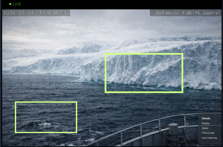
How It Works
Installed in hours, operating for years
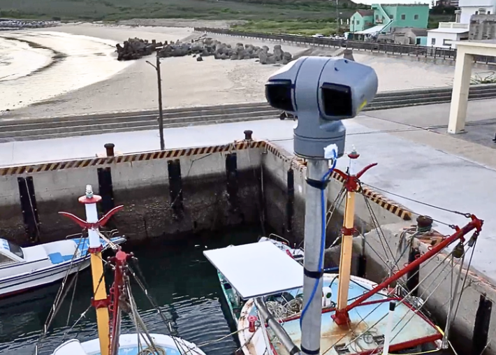
SmartMast is deployed on commercial vessels, where it continuously collects and processes environmental and operational data at the edge. Data is transmitted in near real time to cloud infrastructure, where it becomes accessible via APIs and applications. Each unit integrates on any powered vessel within 2 hours and runs autonomously from there.
360° optical & infrared cameras, 31× zoom up to 10NM
Software-defined radios capturing AIS up to 40NM
Edge-AI processor with 24/7 autonomous scanning
SATCOM for real-time HD video transmission
Learn about SmartMast →A New Data Infrastructure for the Ocean
One platform. Four categories of value.
01
Persistent Environmental Monitoring
High-frequency EO/IR and RF sensing across entire voyages, not just periodic snapshots. SmartMast creates longitudinal datasets across global shipping routes that no satellite revisit cycle can replicate.
02
Regulatory-Grade ESG & Compliance Data
Verifiable, audit-ready data aligned to modern sustainability frameworks. Continuous audit trails supporting IMO, MARPOL, emissions reporting, and ESG disclosure requirements.
03
Offshore Energy & Industrial Operations
Environmental impact monitoring, spill detection, and anomaly identification around offshore assets. Real-time activity awareness for rigs, pipelines, and support vessel operations.
04
Scientific & Climate Intelligence at Scale
Distributed ocean observation across thousands of vessels, generating ground-truth data for climate and oceanographic models without deploying dedicated research infrastructure.
Outcomes
What SmartMast makes possible
SmartMast delivers the data infrastructure required to monitor, understand, and manage the ocean at global scale.
How SmartMast Works
Edge processing on commercial vessels already at sea • Near-real-time transmission to cloud infrastructure • API and application access for analysts and compliance teams • Opportunistic sensing from existing global fleets • Persistent coverage without new infrastructure • Edge-to-cloud data pipelines at global scale
Example Data Products
Geo-referenced EO/IR imagery with GPS metadata • AIS-correlated vessel activity records • Iceberg and maritime hazard detections • MARPOL-reportable cetacean sightings • Wave height and sea-state observations • RFMO-formatted IUU vessel encounter logs
Who Benefits
Shipping ESG & Sustainability Teams • O&G Environmental Impact Management (EIM) • NOAA, NSF & US Federal Science Agencies • ESA, EEA & EU Copernicus Programs • Regional Fisheries Management Organizations (RFMOs) • Flag States & Port State Control • Maritime Underwriters & Risk Analysts
Data Licensing & Agency Partnerships
Structured for compliance calendars and procurement cycles
SmartMast is designed to fit within existing ESG compliance programs, offshore environmental monitoring requirements, and government science procurement cycles, adding to what you already have rather than replacing it.
Whether you need to close an ESG data gap, satisfy a fisheries reporting obligation, or expand a federal oceanographic dataset, we structure deployments around your program timeline and budget.
Partner With Us →Partnership Opportunities
ESG compliance data programs for shipping operators
EIM data licensing for O&G operators
Federal science agency data procurement (NOAA, NSF, EPA)
EU regulatory and science data access (ESA, EEA, Copernicus)